世界灌漑農業アトラス'WAIASS'の開発
WAIASS(World Atlas of Irrigation Agriculture for Sustainability Sciences)は、世界灌漑農地マップをベースとした各灌漑農地の水資源・灌漑諸元・農業生産に関する情報が集約されたアトラス形式のデータベースです。灌漑農業水利用の解析への利用や世界の幅広い分野の関係者との情報共有を目的に、現在開発を進めています。
WAIASSの事例は動画形式でこちらの外部ページのGalleryページからご覧いただけます。主な内容
時系列衛星データ解析プロダクト(2001年〜現在)
主に神戸大で構築地域灌漑農業情報
各国・地域の研究者との相利的ネットワークにより収集- 灌漑履歴
- 灌漑管理情報
- 水源情報
- 農業生産情報
収録地域(2012年現在)
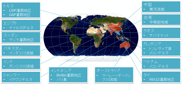
収録地域・内容は共同研究・研究協力者からのリクエストや情報交換によって今後も拡大(成長)します。
ギャラリー
その他の動画はこちらの外部ページのGalleryページからもご覧いただけます。)
メコンデルタのMODIS時系列画像 (2011年5月〜2012年4月)
タイの植生変化と洪水 (2010年5月〜2012年4月)
トルコ・ハラン平原の灌漑農地の植生変化 (2013年1月〜12月)
関連する成果
-
長野宇規, 小寺昭彦 2014
世界灌漑農業アトラスが可視化する水と農業の関係.
土地改良 285: 56-61 -
The changes of land use and flood situation in RIO3 region
Kotera, A., The 5th TRF Water Policy Public Forum"Effective local water resource management for provincial level", held at Century Park Hotel, Bangkok, Thailand, 25 Mar. 2014. -
世界灌漑農業アトラスWAIASSの開発
小寺昭彦、長野宇規、CREST水循環モデリング合同国際シンポジウム「持続可能な水利用の実現に資する水循環モデリング」、東京大学生産技術研究所2014年3月10-11日 -
長野宇規、灌漑農地の動的解析のためのデータセット構築
CREST水循環モデリング合同国際シンポジウム「持続可能な水利用の実現に資する水循環モデリング」、東京大学生産技術研究所2014年3月10-11日 -
Marui, A. Kotera, A., Furukawa, Z., Yasufuku, N., Omine, K., Nagano, T., Tuvshintogotokh, I. and Mandakh, B. 2013
The Result of Vegetation Index Using Satellite Data and Monitoring of Growing Environment of Wild Licorice at Semi-arid Area in Mongolia
Proceedings of Desert Technology 11th International Conference November 19-22, 2013 San Antonio, TX USA. - 時系列衛星データによる水稲冠水被害の判別 小寺昭彦、長野宇規、平成25年度農業農村工学会大会講演会, 東京農業大学, 東京, 2013年9月3-5日
-
Marui, A. Kotera, A., Furukawa, Z., Yasufuku, N., Omine, K., Nagano, T., Tuvshintogotokh, I. and Mandakh, B. 2013
The Result of Vegetation Index Using Satellite Data and Monitoring of Growing Environment of Wild Licorice at Semi-arid Area in Mongolia
Proceedings of Desert Technology 11th International Conference November 19-22, 2013 San Antonio, TX USA. -
Nagano, T., Kotera, A. 2013
Recent trend of drought conciliation and agricultural water use in Japan.
Proceeding of International Workshop on Developing Management Strategies for Coping with Drought and Water Scarcity, First World Irrigation Forum and 64th IEC Meeting of ICID, 29-5 October, Mardin, Turkey, 2013. - Hayriye Ibrikci, Mahmut ?etin, Ebru Karnez, Wolfgang A. Flugel, Manfred Fink, Ramon Aragues, Takanori Nagano, John Ryan and Hande Sagir. Integrated water and nitrogen management in a largie scale irrigated area in southern Turkey. First World Irrigation Forum and 64th IEC Meeting of ICID, 29-5 October, Mardin, Turkey, 2013.
- Mahmut Cetin, Wolfgang-Albert Fl?gel, Hayriye Ibrikci, Takanori Nagano, Burak Tilkici, Ramon Arag??s, Ebru Karnez. Sustainability of Agricultural Water Management: A Case Study in Southern Turkey. First World Irrigation Forum and 64th IEC Meeting of ICID, 29-5 October, Mardin, Turkey, 2013.
-
小寺昭彦,長野宇規 2013
ベトナム・メコンデルタにおける輪中農業のレジリアンスと脆弱性. ARDEC No. 48: 18-22. -
藤田藍斗、小寺昭彦、Satir, O., Berberoglu, S., 長野宇規 2013.
ミクセル分解法を用いたMODISデータセットからの作物別NDVI季節変化の推定
農業農村工学会論文集. 79: 81(5),1-9. -
Tojo, B., Kotera, A., Nakai, K., Nagano, T., Kobayashi, S. and Moji, K. 2012.
Evaluation of recent forest cover change in Savannakhet province, Lao PDR, using satellite imageries and APHRODITE data.
Global Environmental Research. 15: 119-129. -
Kotera, A., Hanittinan, P., Sucharit, K. and Nagano, T. 2012.
Assessing flood damages of rice in the Chao Phraya Delta, using MODIS satellite imageries.
Full paper of PAWEES2012. International conference on "Challenges of Water & Environmental Management in Monsoon Asia", Thailand, 27-29 November - Nagano, T., Kotera, A. and Fujita, A. (2012): Development of World Atlas of Irrigated Agriculture for Sustainability Science. PAWEES 2012 -International Conference on "Challenges of Water & Environmental Management in Monsoon Asia." Nonthaburi, Thailand, 27-28 Nov. 2012.
-
時系列衛星データから見た過去11年間における灌漑農地利用の変化
小寺昭彦, 長野宇規, 平成24年度農業農村工学会大会講演会オーガナイズドセッション、北海道大学 2012年9月 -
Monitoring dynamics of irrigated agriculture using time-series satellite data as reflections of human activities against fluctuations in the regional water resource.
Kotera, A. and Nagano, AOGS-AGU (WPGM) Joint Assembly Resorts World Convention Centre, Singapore.13-17 August 2012. -
Development of World Atlas of Irrigated Agriculture for Sustainability Science
Nagano, T., Kotera, A., Kanae, S., ICID (International Commission on Irrigation and Drainage) & IAL (Irrigation Australia) 2012 Conference, Adelaide, 28 June 2012. - 農業農村工学会全国大会 企画セッション「世界灌漑農業アトラスの開発」, 北海道大学, 札幌, 2012年9月
- Kotera, A. et al., Monitoring dynamics of irrigated agriculture using time-series satellite data as reflections of human activities against fluctuations in the regional water resource, AOGS-AGU (WPGM) ,Singapore, Aug. 2012.
- Nagano, T. et al., Development of World Atlas of Irrigated Agriculture for Sustainability Science. ICID (International Commission on Irrigation and Drainage) and IAL (Irrigation Australia) 2012 Conference, Adelaide June 28, 2012
- Nagano, T., Building consensus among the water users by visualization, Workshop on Environmental Science and Public Understanding, Kobe University, Kobe, 28th Mar. 2012.
- Tojo, B., Kotera, A., Nakai, K., Nagano, T., Kobayashi, S. and Moji, K. (2011) Evaluation of recent forest cover change in Savannakhet province, Lao PDR, using satellite imageries and APHRODITE data, Global Environmental Research, 15(2), 119-129.
- 小寺昭彦ら, 世界灌漑農業アトラスの作成と利用, 環境科学会2011年会シンポジウム, 関西学院大学, 兵庫, 2011年9月.
- Kotera, A. et al., Mapping and assessment of irrigation crop land using satellite imageries for the last decade in the GAP region, International Symposium of Long Term Vision for the Sustainable Water and Land Use, Adiyaman University, Turkey, 22th Sep. 2011.
- Nagano, T. et al., Development of world atlas of irrigated agriculture for sustainability science, International Symposium of Long Term Vision for the Sustainable Water and Land Use, Adiyaman University, Turkey, 22th Sep. 2011.