World Atlas of Irrigated Agriculture for Sustainability Science
Background of WAIASS
Current advances in climate modeling and hydrological modeling enable projections of future water resource availability at high resolution. Decrease of water resource availability would surely have significant negative impact on productivity of irrigated agriculture since it uses 70% of freshwater resource of the world. It is quite difficult however to predict the degree of the impact because relationship between water resource availability and productivity of irrigation districts are non-linear, influenced by many technical and institutional factors. Each irrigation district has its specific location, access to water resource, history of governance, technological evolution and problems in the management. Average farm plot size, intensity of irrigation or drainage canals, topography and farm plot management may all vary. Therefore critical level of water resource availability for each irrigation district can be quantitatively determined only from analysis of the actual record in the past.
Therefore it is important to compile data of the past cropping patterns, productivity, water resource availability and management. We started developing the World Atlas of Irrigated Agriculture for Sustainability Science (WAIASS) for scientists and practitioners to contribute to sustainability analysis, integrated water resource management, strategic planning, etc.
More examples of WAIASS image or movie are available from here.
Design of WAIASS
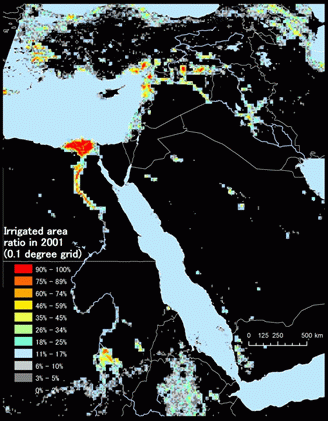
Currently there are two types of digital global maps of irrigated area, provided by FAO and IWMI, respectively. Digital Global Map of Irrigation Areas provided by FAO (Siebert et al.; 2006, hereafter referred as FAO-GMIA) is created from statistical data of each country. The first version was disclosed in 1999 (D?ll and Siebert, 1999) and the current version is for the year 2000. FAO-GMIA provides ratio of irrigated area in each grid. Since the data relies on statistics of each country, the provided area is the "irrigable area" rather than "actually irrigated area". Global Irrigated Area Map provided by International Water Management Institute (Thenkabail et al.; 2006, hereafter referred as IWMI-GIAM) was created from remotely sensed data. This map also provides irrigation map in 1999 together with information on types and intensities of irrigation. IWMI-GIAM provides "actually irrigated area" and the map covers the countries where statistics are not available. The shortcomings of IWMI-GIAM are incompatibility with statistics and uncertainties in accuracy resulting from mixed pixels and clouds.
The main difference between the current maps and WAIASS is that WAIASS is capable of providing irrigation land use every year from 2001 to present whereas current maps stand for one specific year. The attributes to be included in the database are the followings:
- maps of irrigated agriculture (from 2001 to 2010, resolution; 500 m)
- cropping pattern (statistics and calculations)
- distribution of crop productivity in each district
- water source, irrigation method, irrigation uptake (where available)
Materials and methods
To create the maps, 8 days-interval time-series data were used, acquired by MODerate resolution Imaging Spectroradiometer (MODIS, resolution; 500 m) since 2000 up to present. In order to reduce the cloud noise effect and to extract characteristics of the vegetation dynamics, Harmonic Analysis of Time Series (HANTS) algorithm (Roerink et al., 2000) was performed on time-series Enhanced Vegetation Index (EVI). Land Surface Water Index (LSWI, Sakamoto et al; 2007) was then generated and analyzed to detect irrigated fields and inundated areas.
Prospects and Challenges
We intend to create regional information of the irrigated agriculture which contributes to various stakeholders for their sustainability analysis, integrated water resource management, strategic planning etc. Spatial and temporal abundance of MODIS data can provide dynamic view towards change in land use and impacts of extreme whether events on agricultural productivity. The technical challenges lie in decomposition of mixed cells where farm plots are much smaller than the resolution of the images and in the noise reduction of long-term cloud interference especially in the tropical region.
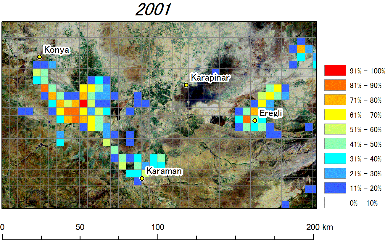
For creating reliable information, validation of land use patterns and collection of management-related data are crucially important. These processes are being carried out through collaborations with the experts of the each country. Our current intensive study areas are Lower Seyhan Irrigation Project and GAP in Turkey; Murray Darling River Basin in Australia; Royal Irrigation District 12 in Thailand; and Mekong Delta in Vietnam. Based on the experiences from these study areas, we try to enlarge the coverage gradually. We create time-series images upon request and we are seeking for new collaborators. Please feel free to contact us.
We will disclose the obtained data on the web upon agreement with the collaborators. In the long term, our database would provide valuable validation data to global and regional hydrologists for their models.